NOTE - DUE TO SEISMIC ACTIVITY IN ICELAND BOTH GRINDAVIK TRANSMITTERS ARE CURRENTLY SHUTDOWN
Naval Radio Transmitter Facility (NRTF) Grindavik is the US Navy / NATO transmission site on Reykjanes Peninsula in Iceland. The site is known to be a critical element of the fixed submarine broadcast system. The facility's mission is to operate and defend secure and reliable communications for United States Strategic Command and Commander, Submarine Forces to support United States Navy and NATO fleet assets across the Atlantic, Pacific and Arctic area of responsibility. NRTF Grindavik is remotely located approximately 13 miles from the NATO Base at Keflavik.
Site entrance from Fjarskyptstöð road

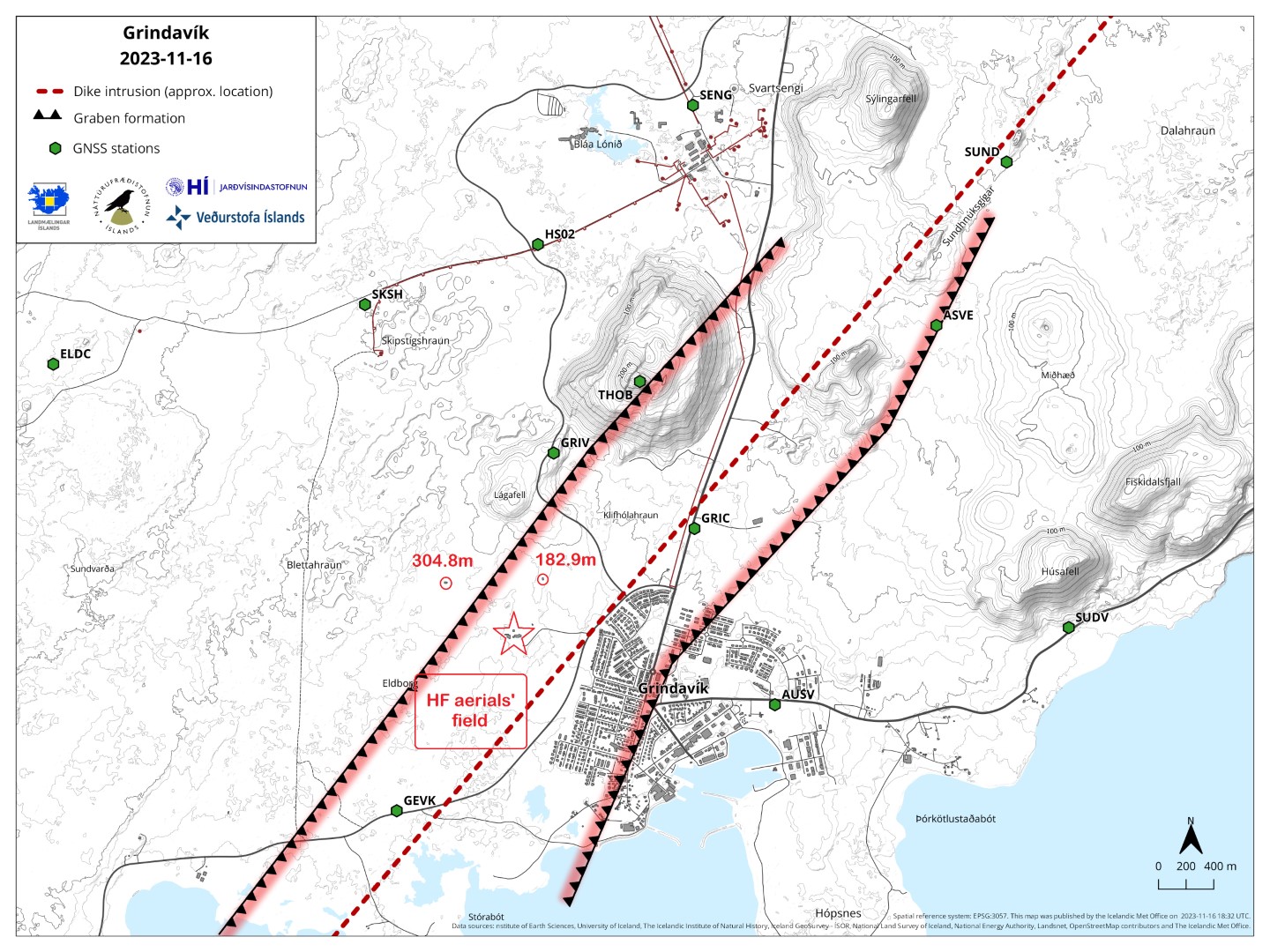
NRTF Grindavik has two Low Frequency insulated antenna towers - the East tower with a height of 182.9 metres, which has been re-built in 1983 with material from the closed down LF site in Londonderry, Ireland; the West tower re-built in 1993 with a height of 304.8 metres, now the second tallest structure in Iceland. The site's transmitters broadcasts on the Very Low Frequency/Low Frequency channels of 37.5kHz and 57.4kHz using MSK 100/200bps modulation.
An approach from Fjarskyptstöð road

A view from 426, Bláa lónið road

An aerial view by Olga Ernst

Due to their high latitude location, Grindavik transmitters are very well suited for monitoring auroral disturbances on the path to Ireland. During dark, the transmitted signals are reflected/refracted from the lower ionosphere (skywave) and, if the ionosphere is disturbed, e.g. by a geomagnetic storm, that affects the received signal's amplitude, resulting significant level of graphs' deflection.


Grindavik town, the eastern 182.9 metres NRTF mast is visible on the left

On November 11th 2023, both Grindavik transmitters were shutdown, due to serious seismic activity on the Reykjanes Peninsula and around Grindavik coastal town in particular. The town itself was evacuated having concerns of coming volcanic eruption. The map below shows approximate location on dike magma intrusion (red line).

An updated map showing graben formations and more detailed NRTF compounds affected
This article's images courtesy of Google, Olga Ernst, The Icelandic National Broadcasting Service and Veðurstofa Íslands (Icelandic Meteorological Office)
All credits for the below historical article of the US/NATO presence in Iceland belongs to:
Michael R. "MO" Morris, CTOCS, USN, Retired CTO SeaDogs WebSite Manager, CTO SeaDogs DataBase Manager, CTO SeaDogs Historian Waldorf, Maryland
===================================================================================
Keflavik, Iceland
Keflavik, Iceland is located on the Reykjanes peninsula on the south-west portion of the island, approximately 50 km from Reykjavik, the capital of Iceland. On a clear day, one can easily see Reykjavík across the bay. Iceland is the second-largest island in Europe, measuring 39,000 square miles in area and is crossed by the Arctic Circle at it's northernmost point. The landscape is characterized by mountains, with uninhabited and rugged interior highlands. On the north and east coast there are sharp and deep fjords, while on the south there are plains and sands. Iceland is a beautiful, unspoiled country. The landmass is often referred to as the "Land of Fire and Ice", due to the island's raging volcanoes, thermal volcanic springs, and vast sheets of ice. Born from the sea by volcanic forces around 18-20 million years ago, Iceland is the youngest country in the world. Iceland has more than two dozen active volcanoes that regularly erupt and add more lava and ash to the landscape. While eruptions often consist of little more than a spit of smoke and a cough of ash, sometimes they can mean spectacular and dangerous geologic fireworks. In the late 18th century, for instance, Iceland's Mount Lakagigar produced the world's largest lava flow -- more than 3 cubic miles of molten rock. Thousands of farm animals were gassed to death by the mountain's poisonous fumes, and the eruption produced so much ash that the sky was dark for weeks. The eruption wreaked havoc on the island's food supply, causing a famine; more than a third of Iceland's people died.
Iceland is a volcanic island, it's forces are still very active, with an eruption in progress somewhere in the country for one out of every five years during the historical period. It's most famous volcano, Mount Hekla, is still active and has erupted three times in the last 20 years, once in 1970, once in 1980 and again in 1991.
Thirteen percent of Iceland is covered with glacial ice. Geothermal activity is a natural resource that has been put to use in the heating of homes, swimming pools and industries. Due to the number of waterfalls available, hydro-electricity is a main power source. Only about 10% of Icelanders have surnames or family names. The rest use the system of patronymics, i.e. instead of a surname, the first name of the father is used, with a "son" or "dottir" (son / daughter) added to it. An example would be the children of Leikur would be Einar Leikurson or Helga Leikurdottir. The Icelandic people are addressed by their first names and listed in the telephone directory as such.
Average temperatures range from 32 degrees in January, to 51 degrees in July. Each winter, it was not unusual to experience at least one "white-out" condition, in which literally everything is covered with snow, to the point where only the snow can be seen. Buildings, vehicles and landmarks disappeared, and all military personnel were confined to quarters. Walking bent over "into the wind" was commonplace in the winter, as 65 mile an hour winds for days on end, were typical. When the winter season came to a close, and the temperatures rose into the 40's, it was not unusual to see off-duty military personnel stationed on Keflavik, in shorts and tee-shirts, firing up their barbecue grills, finally able to conduct outside activities.
Due to its location, only shortly south of the Arctic Circle, Iceland receives only four hours of daylight per day in the depth of winter, and during the summer the nights are almost as bright as the days. In the winter (October through March), the sun, even at its zenith, never managed to rise more than twenty or so degrees above the horizon. Winters are almost perpetually night, and during the summer (April through September), almost perpetually daylight. This made for some unusual conditions and sights. In the summer, softball games played outdoors, starting at midnight; and black shades on windows to keep out the intense sunlight during normally night hours, so as to sleep in the dark. In the winter, looking forward to the 3-4 hours of daylight, and planning events to coincide; and while driving, never bothering to turn off your headlights, even during the day, as it will be dark by the time you get wherever you are going. Keflavik, and the surrounding areas had no trees, shrubs or even weeds; virtually no grass, plants nor vegetation of any kind. The local geography is dominated by fields of basalt rubble, and flat ground areas, with a hard layer of dirt over volcanic rock. Plants didn't grow there.
In the height of the Cold War, U.S. forces on Iceland served to protect against Soviet submarines. The U.S. had a military presence in Iceland starting in 1941, and a formal defense agreement with that nation since 1951. The Navy assumed the responsibility of running the air station from the U.S. Air Force in 1961. The base acted as a platform for several operational capabilities throughout World War II, the Cold War and in the modern arena. The hangars housed rotational P-3 Orion aircraft and crews in support of anti-submarine warfare until 2004. The Army National Guard units and Interim Marine Security Forces stormed the lava fields surrounding the base during training exercises such as Northern Viking. The flight line served as a launching point for U.S. Air Force F-15 fighters.
After receiving independence from Denmark in 1918 with the signing of the 25-year Danish-Icelandic Act of Union, Iceland followed a policy of strict neutrality. In 1939, with war imminent in Europe, the German Reich pressed for landing rights for Lufthansa's aircraft for alleged trans-Atlantic flights. The Icelandic government turned them down. A British request to establish bases in Iceland for the protection of the vital North Atlantic supply lines after German forces occupied Denmark and Norway in April 1940, was also turned down, in accordance with the neutrality policy. Therefore, it was a rude surprise for the people of Reykjavík to awaken to the sight of a British invasion force on May 10, 1940. The country's strategic importance to the British was understood; what was annoying to Icelanders was the lack of consultation. Iceland protested the use of military force by Britain, but immediately accepted the fait accompli. Following talks between British Prime Minster Winston S. Churchill and President Franklin D. Roosevelt of the U.S., Iceland agreed to a tri-partite treaty under which the United States was to relieve the British garrison in Iceland, on the condition that all military forces be withdrawn from Iceland immediately upon the conclusion of the war in Europe.
The first U.S. military involvement in Iceland dates back to 1941, when the Marines arrived. The forces were replacements for the British garrison that was stationed in Iceland after the British occupation in May of the previous year. In addition to their defense role, U.S. forces constructed the Keflavik Airport as a refueling point for aircraft deliveries and cargo flights to Europe. Another agreement signed between the U.S. and Iceland in 1946 permitted continued use of the Keflavik Airport (later the site of the Keflavik International Airport) for flights in support of occupation forces in Europe. At the peak of the Second World War, thousands of troops were stationed at Keflavík in temporary Quonset hut camps.
Following World War II, as promised, all U.S. military personnel were withdrawn from Keflavik, as specified in the original agreement. During 1947-51, the base was operated by a U.S. civilian contractor company (Lockheed Aircraft Overseas Service) as an international airport. Most of the temporary structures were salvaged or too badly deteriorated for use. The airfield complex, one of the largest in the world during World War II, also required upgrading to accommodate modern aircraft. The contractor company had extended one runway, constructed a new passenger terminal and hotel building, one aircraft hangar, a hospital, housing units and other facilities for the staff. The airfield was extended and two new aircraft hangars were constructed. Most of this work was completed by 1957.
Iceland´s charter membership in NATO in 1949 required neither the establishment of an Icelandic armed force, nor the stationing of foreign troops in the country during peace time. However, the Cold War with the Soviet Union, and growing world tensions, caused Iceland´s leaders to think otherwise. Icelandic officials decided that membership in the NATO alliance was not a sufficient defense and, at the request of NATO, entered into a defense agreement with the U.S. This was the beginning of the Iceland Defense Force. During the next four decades, the Defense Force was "at the front" of the Cold War and was credited with playing a significant role in deterrence.
On July 1, 1961, the U.S. Naval Communication Station, (NAVCOMMSTA) Iceland was established and assumed most of the island’s military communications requirements from the Airways and Air Communications Service Squadron (AACS/MATS). The NAVCOMMSTA’s responsibilities were wide-ranging with personnel assigned to operate communications equipment at a variety of remote sites: Inter-Island TROPO site at H-1; DYE-5 Transceiver site; transceiver sites at H-2 and H-3, the Special Communications (SPECOMM) at H-2; and Naval Radio Transmitter Facility (NRTF) Grindavik. In 1968 the Receiver Site was relocated from the Garrity building, which had served as a receiver site since 1948. In late 1991, the Naval Communication Station was redesignated an U.S. Naval Computer and Telecommunications Station (NCTS).
On March 18, 1959, an advance party arrived, and U.S. Naval Security Group Activity Keflavik was formally commissioned on April 25, 1959. The command was initially located in an Operations building near the village of Hafnir, Iceland. In November, 1967, the command assumed the function of a CRITICOMM relay station, using spaces in Hanger 831, onboard Naval Air Station Keflavik. The NSGA Special Operations building was completed in April, 1970 at the Rockville site.
The U.S. Naval Security Group Activity Keflavik maintained and operated a high frequency direction finding (HFDF) facility and provided communication support to Navy and other Department of Defense elements. NSGA Keflavik maintained an AN/AX-16 Pusher Wullenweber, which is a 2-band Circularly Disposed Dipole Array (CDDA) HFDF collection system, which was installed in the summer of 1979 at the Rockville site. The AN/AX-16 Pusher is a miniaturized version of the Navy's AN/FRD-10 antenna. The outer ring of elements is about 400 feet in diamter, half the diameter of the AN/FRD-10 CDAA Wullenweber Antenna Array. The Operations Building was located approximately 500 yards distance from the CDDA. The CDDA has since been removed.
In the summer of 1979, after the AN/AX-16 Pusher antenna became operational, all of the operational, administrative, communications and facilities functions were consolidated at the Special Operations Building at the Rockville site. The Communications Center in Hanger 831 was turned over to Commander, Fleet Air Keflavik (CFK). The old Operations building at Hafnir was turned over to NAS Keflavik.
NAS Keflavik was the host Command for the NATO Base in Iceland. There were more than 25 different commands of various sizes and personnel from the Navy, Air Force, Marines, and Army in Iceland. Also present were representatives from Canada, the Netherlands, Norway, and Denmark. One of the largest commands was Naval Air Station (NAS) Keflavik, which was responsible for providing all support facilities, including the runways, housing, supply and recreational facilities, to name a few. NAS Keflavik employed approximately 900 Icelandic civilians, who worked with military personnel to provide the services necessary to operate the base. Twenty-four hours a day, seven days a week, the airfield was available for maritime patrol activities, air defense and for transiting aircraft between North America and Europe. The runways operated by NAS Keflavik were shared with the Keflavik International Airport.
The major commands stationed on the base were the Naval Air Station Keflavik; the Air Forces 85th (Fighter) Group; Commander, Fleet Air Keflavik; Commander, Iceland Defense Force; NCTS Keflavik, Naval Hospital Keflavik, and the Marine Corp Security Force Company, Keflavik.
The U.S. Air Force had about 2,000 active-duty airmen stationed with the 85th Group at NAS Keflavik. The air defense mission is carried out by F-15 Eagle fighter aircraft rotating every 90 days to Iceland. Using four ground-based radars and occasionally AWACS (Airborne Warning and Control System) aircraft, the 85th Group’s 932nd Air Control Squadron provided air surveillance of Iceland and the North Atlantic.
The NATO base offered a wide variety of recreational services, including: bowling, swimming, gymnasium, theater, social clubs, Wendy's restaurant, and hobby centers. Other services included a base exchange, commissary, bank, hospital, beauty shop, video rentals, USO, service clubs, tour office and morale flights. In the late 1980's,before a Wendy's was located on Keflavik, the USO sponsored an event, one day a year, when hundreds of McDonald's Big Macs and Quarter Pounders were flown in from Norfolk, VA, and sold to Soldiers, Sailors, Airmen, Marines, and their families on base. The line to obtain this precious commodity stretched around the base. Proceeds went to the USO.
NSGA Keflavik was decommissioned and closed on June 30, 1994. NSGA was located approximately 8 miles from NAS Keflavik, one mile from the U.S. Air Force 932nd Air Defense Squadron facility, and adjacent to the Naval Computer and Telecommunications Station Keflavik, Rockville Receiver Site. The Rockville Receiver Site was fully remoted on March 14, 1997; and was closed in October, 1999.
Naval Air Station Keflavik (NAS) disestablished on September 8, 2006 during a ceremony officially ending its 45 years of operations, in support of the defense of Iceland. More than 100 Sailors attended the event, representing a majority of the forces that remained of a population that once exceeded 5,000 military and civilian personnel and family members. Special guests included the U.S. Ambassador to Iceland, Carol Van Voorst and special envoy for Iceland’s Minister of Foreign Affairs, Thorsteinn Ingolfsson. NAS Keflavik officially closed on September 30, 2006.